
onX maps: A GPS app for hunters

onX is a one-sided platform for outdoor enthusiasts. It combines GPS technology with public records to provide data in an intuitive, integrated, and visually rich format.
onX maps is a one-sided platform for outdoor enthusiasts. It combines publicly available information with data analytics to present visually rich information to users both in desktop and mobile app form. This platform is innovative in that it decreases friction between the users of the app and the information they seek.
Main Features:
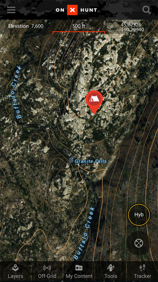
- Visual identification of land owners
- Public/Private land border identification
- GPS Navigation with live tracking and waypoint creation
- Multi-layered maps including topography
Market Opportunity
This app creates value for a group of consumers not frequently targeted by tech firms: Hunters.
Over 38MM people hunt and fish in the United States. Among outdoor enthusiasts, hunters have a high willingness to pay: The average hunter spends ~$2,500 annually and hunters overall contribute $2.9Bn annually to support wildlife and wildlife agencies.

The use of publicly available information and GPS technology allows onX to compete with nonconsumption and serve the pain points of consumers that are underserved by alternatives, such as Google Earth or AllTrails.
Value Creation
A common challenge for hunters is locating and becoming familiar with areas to hunt.
Public Land
Many hunters hunt on public land – that is, land owned by the Federal or State governments. The US federal government alone has made 640MM acres of land available for public use.
Knowing land boundaries is extremely important for hunters – unknowingly wandering onto private land constitutes trespassing and is a crime, regardless of intent. In practice, however; it can be difficult to determine the location of land boundaries in the field because:
- Boundaries are frequently not clearly demarcated by fencing or other markers
- If demarcated, boundaries may not be visible because of thick vegetation
- Tracts of public land may have odd shapes or even be non-contiguous
onX solves this problem by allowing the user to see, live on their device, where they are in relation to the boundaries on a particular tract of land. This feature is available for all tracts of land, including 985MM acres of public land.
Private Land
Private land is owned by hunters or by third parties who grant a hunter permission to use their land. These third party landowners commonly grant hunting permission when wildlife are:
- Damaging crops, such as deer or black bear eating corn fields when other food sources become scarce
- Damaging property, such as feral hogs destroying fields by rooting for food
- Threatening people or animals, such as coyotes preying on pets or livestock
In the case of third parties, a hunter must seek permission from the land owner to hunt on the property. This presents a challenge for new hunters or experienced hunters moving to a new area, as they have not developed relationships with local property owners and likely do not know the owners of uninhabited property. Ownership and contact information is publicly available, but not always in a visually intuitive format.
Onx solves this problem by visually displaying landowner information directly in the GPS app. This saves users a considerable amount of time.
Navigation
Many hunters hike into remote, undeveloped areas of wilderness that are accessible only on foot or via pack animal. Void of trails and unique landmarks, these landscapes make it difficult to maintain a navigational bearing, especially at night.
onX solves this problem by allowing the user to save waypoints and plot their path so that they can follow this digital trail back to camp and return the following day.
This platform smoothly integrates the functionality of many other apps into one platform, making it immensely valuable for it’s users. This value is clear for the millions of Americans who hunt, fish, camp, or hike, especially those who do so in remote areas.
This is a fascinating product that clearly solves an unmet need for the hunters out there. I could also see this app/platform increasing the adoption of hunting as a pastime for people who have always been interested but faced the barrier to entry of finding a place to hunt (or used to hunt, but have moved to new places that aren’t familiar to them). Ultimately, it seems like this platform may increase the “size of the pie” for the hunting industry as a whole, which is quite a unique value proposition and a good reason for several players within the industry to support it and push for its wider adoption.